Building the State coordinate - elevation networks 1st, 2nd, 3rd, 4th class with the gravity network, astronomic network in the whole country. Establishing the topographical maps of 1:2000 scale in Hanoi Capital. Surveying the topographical maps of 1:2000, 1:10000 scales and surveying the works in service of the design, the construction of Hoa Binh, Ta Phu, Tri An, Thac Mo, Song Hinh, Song Con...hydroelectric works . Surveying, establishing the topographical maps of 1:2000 and 1:5000 scales in Ho Chi Minh City , Long An, Tien Giang and Vinh Long provinces.
From 1988 to 1994
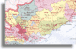
Continuing surveying, establishing the topographical maps of 1:2000 scale in HoChiMinh urban area. Surveying the topographical maps of 1:5000, 1:10000 scales in the provinces of the East of South Vietnam, south Song Be, the provinces of the Mekong River Delta. Surveying the topographical maps of 1:5000 and 1:10000 scales, in service of the planning of the triangular economic zone (Ho Chi Minh city- Bien Hoa Vung Tau) of the Government in 1991-1992. Surveying the topographical maps of 1:10000 scales in the provinces of Dong Nai, Ba Ria - Vung Tau (including Con Dao), Binh Thuan. Taking part in the fully-made achievement and modernization of the astronomic, geodesic networks, in the whole country of the year 1992-1993. Surveying the topographical maps of 1:2000, 1:10000 scales and surveying the works in service of the design and the construction Ham Thuan hydroelectric works. Surveying the seabed topographic maps of Vung Tau, Con Dao zone.
From 1994 to 1999
Building the administrative border maps and documents of the provinces, cities in the whole country according to the instructions No. 364 dated January 6, 1991 of the chairman of the council of Ministers. Participation in the construction of the State co-ordinate networks at zero rank, construction of the basic Cadastral Networks for some provinces and cities. Execution of Cadastral networks, surveying and establishing the cadastral dossier at various scales in service of the issuance of the certificate of the right of use of agricultural land, forestry land and urban land for provinces, cities in the whole country. Carrying out many other works, technical economic projects in the field of surveying maps .
Since 1999 up to now
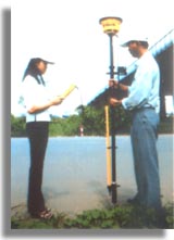
Building the basic Cadastral Networks covering the Nation wide with GPS technology. Finding for repairing the coordinate-elevation land-mark of 2nd class and the elevation networks of 1 st , 2 nd class in the whole country. Modernization of the State Elevation Networks 1 st , 2 nd , 3 rd class in the whole country. Building the Cadastral network; surveying the maps and establishing the Cadastral dossier issuing the certificate of the right of use of the agricultural, forestry land; and dwelling- land in country town and dwelling land in the countryside for 52 provinces, cities. Building the cadastral networks, surveying urban cadastral maps of 1:200, 1:500, 1:1000 scales for ten urban districts and two suburban districts in Ho Chi Minh City. Surveying the topographical maps of 1:2000, 1:5000 scales with the digital technology in Ho Chi Minh City area. Building the Geographic database of the topographic foundation following the administrative line in all levels in Ho Chi Minh City. Surveying, establishing the topographical maps in service of the design the construction of many hydroelectric works, industrial works, civil works in the whole country. Planning of the land use at the district, commune levels for some provinces in the West of South Vietnam. Construction of the database of Land Information Systems (LIS) at the ward, commune, district levels for the localities. Surveying the basic cadastral maps of Gia Lai province. Implementing the project of the construction of the topographic, hydrographical foundation of the Mekong Delta.